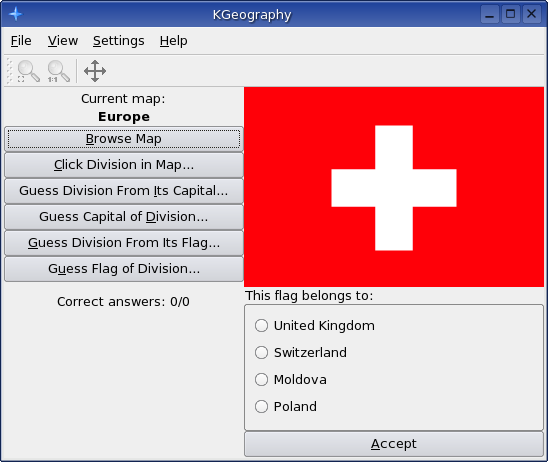
Description: KGeography is a geography learning tool. Right now it has six usage modes: - Browse the maps clicking in a map division to see it's name - The game tells you a map division name and you have to click on it - The game tells you a capital and you have to guess the division it belongs to - The game tells you a division and you have to guess its capital - The game shows you a map division flag and you have to guess its name - The game tells you a map division name and you have to guess its flagLast changelog:
New maps included: Asia Austria Brazil Canada China Italy by provinces Netherlands Norway Poland World
I like kgeography. And it's already optimal for the single country maps (showing the states of the country). But most times I want to take a look at the world map and that's the point where wishes starts.
There are several feature requests in the bug tracker of kgeography. Some examples:
- Use SVG where possible for KGeography
- mark capitals in the map
- drag map with right mouse button
- zoom in and out with mouse wheel and keyboard
These features and more are already implemented in marble. Marble has also a political map - just chose "Plain Map" and disable cities, terrain and water bodies. In the latest version of marble you can also change the projection from globe to flat map.
If I'm not completely wrong, marble will become a flexible component of KDE 4. So everybody will be able to integrate it in his application.
I think if KGeography would use the marble widget for showing the world map, both projects would benefit from each other, because the marble developers want there project to be used by other applications and kgeography could benefit of new marble features and maps.
What do you think?
Hey,
very nice tool, but there seems to be something wrong with the netherlands.
It asks for Poland and so on when I click "Klicken Sie ein Land auf der Karte an ...". Sry, I only got the German version on my Ubuntu.
Kind regards from Germany
LinuxMachine
Hello! I tried to install it in Gnome, but it gives me a missing dependencies error. Is there a way to do it without KDE? (I am a newby by the way...)
Thanks!
nice app, but I think that changing the map is not so intuitive... I took some time to discover that it is done by File-Open. Perhaps you could add a button "change map" or something like that.
Beside this functionallity, what about making sthg. like an "fly-over", where all interesting infos are asked?
And at the end, you get a summary of your knowledge?
This way would connect the informations in a more visual way..
P.e.:
starting in denmark, showing the capitol-city and the east and north-sea and legoland(a must for childrens, i think ;-)).
Going on to germany over hamburg, showing the river elbe and perhaps some important buildings...etc
As far as I know, there is no other Linux application that does what KGeography does, so this should prove very useful.
At the moment, the quizzes do not tell you which questions you got right or wrong do they?
No, it does not tell you which questions you failed, i am currently thinking how to implement it, my options are:
1 - Tell the error when you fail the answer
2 - Tell the error when you fail the answer and tell the correct answer
3 - Tell all the errors you made once you answer all the questions
4 - Tell all the errors you made once you answer all the questions and tell the correct answers
5 - Don't let you pass a question until you answer it correctly (greying out previously failed answers)
Right now what i like the more is 3 and 5, any suggestion?
Personally I prefer methods 2 or 5, but that's just my opinion.
Another feature that you could aim to implement in the future could be a sort of 'practice' mode that allows you to click on any country to see some data on it, perhaps data that's updated from the net?
If you are needing information to display (such as flags, world, national, and state maps, continent, etc), you can always use: http://www.cia.gov/cia/publications/factbook/index.html
Use perl/python and rip the info. For the most part, it is probably close to accurate.
Some time ago, I was going to build a multi-tier monopoly game that would allow you to move up only if you conquerored lower tiers. Each board was to represent a state -> nation -> continent -> world. The idea on that was to use geo and cultural info for the boards.
Thanks for telling but already knew of it. For flags i prefer to use sodipodi flags collection and for maps i'm already using it but not directly as they need some preprocessing to make sure each country has a different color, etc


Ratings & Comments
17 Comments
I like kgeography. And it's already optimal for the single country maps (showing the states of the country). But most times I want to take a look at the world map and that's the point where wishes starts. There are several feature requests in the bug tracker of kgeography. Some examples: - Use SVG where possible for KGeography - mark capitals in the map - drag map with right mouse button - zoom in and out with mouse wheel and keyboard These features and more are already implemented in marble. Marble has also a political map - just chose "Plain Map" and disable cities, terrain and water bodies. In the latest version of marble you can also change the projection from globe to flat map. If I'm not completely wrong, marble will become a flexible component of KDE 4. So everybody will be able to integrate it in his application. I think if KGeography would use the marble widget for showing the world map, both projects would benefit from each other, because the marble developers want there project to be used by other applications and kgeography could benefit of new marble features and maps. What do you think?
Hey, very nice tool, but there seems to be something wrong with the netherlands. It asks for Poland and so on when I click "Klicken Sie ein Land auf der Karte an ...". Sry, I only got the German version on my Ubuntu. Kind regards from Germany LinuxMachine
Hello! I tried to install it in Gnome, but it gives me a missing dependencies error. Is there a way to do it without KDE? (I am a newby by the way...) Thanks!
kgeography-0.4-SuSE10.0.i586.rpm at http://home.tiscali.be/raoul.linux/download.htm ENJOY !!!
On a Suse 10.0 joins the error : if g++ -DHAVE_CONFIG_H -I. -I. -I../.. -I/opt/kde3/include -I/usr/lib/qt3/include -I/usr/X11R6/include -DQT_THREAD_SUPPORT -D_REENTRANT -Wno-long-long -Wundef -ansi -D_XOPEN_SOURCE=500 -D_BSD_SOURCE -Wcast-align -Wconversion -Wchar-subscripts -Wall -W -Wpointer-arith -O2 -Wformat-security -Wmissing-format-attribute -Wno-non-virtual-dtor -fno-exceptions -fno-check-new -fno-common -DQT_CLEAN_NAMESPACE -DQT_NO_ASCII_CAST -DQT_NO_STL -DQT_NO_COMPAT -DQT_NO_TRANSLATION -MT mapwidget.o -MD -MP -MF ".deps/mapwidget.Tpo" -c -o mapwidget.o mapwidget.cpp; \ then mv -f ".deps/mapwidget.Tpo" ".deps/mapwidget.Po"; else rm -f ".deps/mapwidget.Tpo"; exit 1; fi mapwidget.cpp:332:25: error: mapwidget.moc: Aucun fichier ou répertoire de ce type make[2]: *** [mapwidget.o] Erreur 1 make[2]: Leaving directory `/home/raoul/work/kgeography-0.4/kgeography/src' make[1]: *** [install-recursive] Erreur 1 make[1]: Leaving directory `/home/raoul/work/kgeography-0.4/kgeography' make: *** [install-recursive] Erreur 1
nice app, but I think that changing the map is not so intuitive... I took some time to discover that it is done by File-Open. Perhaps you could add a button "change map" or something like that.
kgeography-0.3-s92k34b.i586.rpm at http://home.tiscali.be/raoul.linux/download.htm
Nice app; I thought you'll also like the following links: http://www.sheppardsoftware.com/states_experiment_drag-drop_Intermed_State15s_500.html http://www.lizardpoint.com/fun/geoquiz/euroquiz.html http://www.lizardpoint.com/fun/geoquiz/afrquiz.html Thanks for your work, ce
I built a rpm for SuSE 9.1 ... I wrote an email to the adress that is standing on the hompage. Maybe you can use it... Raphael 'Hubble' Errani
Beside this functionallity, what about making sthg. like an "fly-over", where all interesting infos are asked? And at the end, you get a summary of your knowledge? This way would connect the informations in a more visual way.. P.e.: starting in denmark, showing the capitol-city and the east and north-sea and legoland(a must for childrens, i think ;-)). Going on to germany over hamburg, showing the river elbe and perhaps some important buildings...etc
As far as I know, there is no other Linux application that does what KGeography does, so this should prove very useful. At the moment, the quizzes do not tell you which questions you got right or wrong do they?
No, it does not tell you which questions you failed, i am currently thinking how to implement it, my options are: 1 - Tell the error when you fail the answer 2 - Tell the error when you fail the answer and tell the correct answer 3 - Tell all the errors you made once you answer all the questions 4 - Tell all the errors you made once you answer all the questions and tell the correct answers 5 - Don't let you pass a question until you answer it correctly (greying out previously failed answers) Right now what i like the more is 3 and 5, any suggestion?
Personally I prefer methods 2 or 5, but that's just my opinion. Another feature that you could aim to implement in the future could be a sort of 'practice' mode that allows you to click on any country to see some data on it, perhaps data that's updated from the net?
Do you make use of Kdeduca?
No, why do you ask?
I like it.
If you are needing information to display (such as flags, world, national, and state maps, continent, etc), you can always use:
http://www.cia.gov/cia/publications/factbook/index.html
Use perl/python and rip the info. For the most part, it is probably close to accurate.
Some time ago, I was going to build a multi-tier monopoly game that would allow you to move up only if you conquerored lower tiers. Each board was to represent a state -> nation -> continent -> world. The idea on that was to use geo and cultural info for the boards.
Thanks for telling but already knew of it. For flags i prefer to use sodipodi flags collection and for maps i'm already using it but not directly as they need some preprocessing to make sure each country has a different color, etc